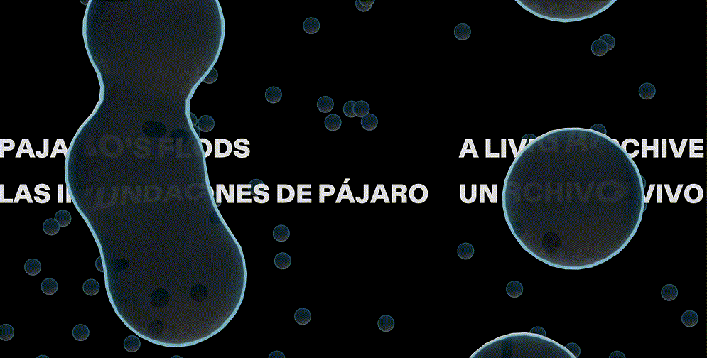
Pajaro’s Floods: A Living Archive reimagines climate storytelling by blending spatial data and personal narratives to examine the layered factors - current, historical, and environmental - surrounding flooding in California’s Pajaro Valley. Through LiDAR scanning, photogrammetry, GIS, interviews, scientific and community archives, this interactive web project makes visible the human and systemic forces shaping the region. It centers the stories of immigrant and farmworker communities whose lives have long been influenced by the Pajaro River and its division along county lines. The collective map and toolkit invite continued contributions, creating a space for communal memory grounded in place and offering a template for future climate storytelling models.
Roles Creative Director and UX Designer Skills Creative direction, 3D modelling and prototyping, UX design, narrative storytelling, project and product management, grant writing Team Rowan Ings (Creative Director and Producer), DXR Zone (Development and UI), Eugenia Renteria and Carlos Campos (Local Producer), Juanita Fonseca Duffo, Xavier Martinez, Eugenia Renteria, Yesica Guzman, Maria Rodriguez (Translation), Taylor Goss (Sound), Iris Fung (Illustration)
In March 2023, waters breached the southern banks of the Pajaro River, causing severe flooding in the agricultural town of Pajaro, California. For this community, it was yet another incident in a long history of flooding. This event brought to the forefront conversations about the continuing infrastructure, socioeconomic disparities, environmental and governance challenges stemming from the river and its role as a dividing line between Santa Cruz and Monterey counties.
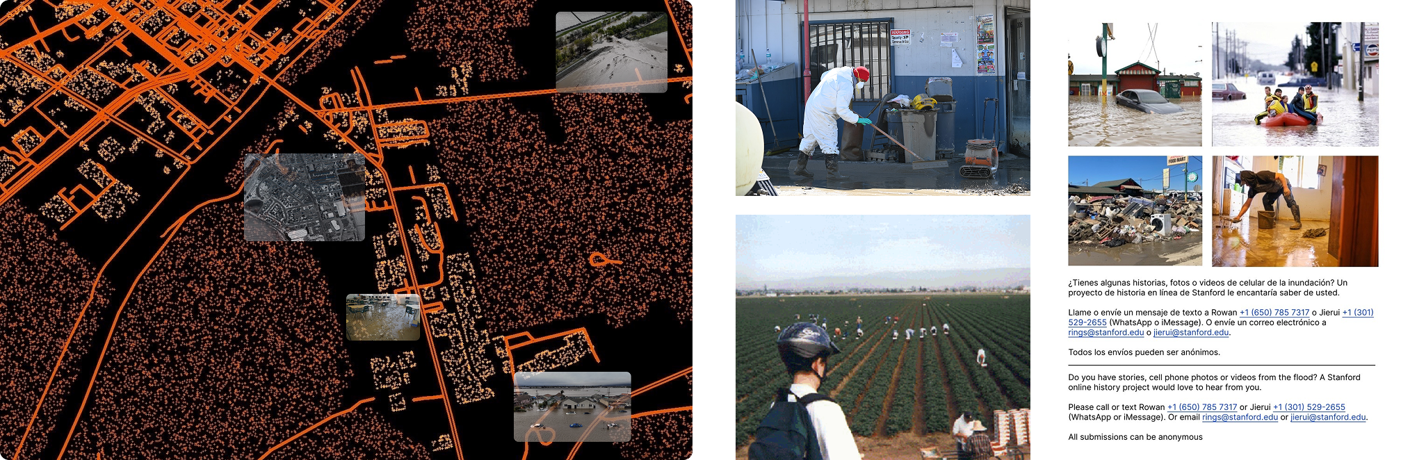
Collateral used in community reach outs
Initiation and Funding
This project began as an independent collaboration between filmmaker Rowan Ings and me. Together, we envisioned a web documentary that amplifies resident stories and frames the floods within broader environmental and infrastructural systems, using spatial storytelling to illuminate the systemic and place-based dimensions of this climate event and ground it in key community landmarks. I played a key role in securing funding, including drafting grant proposals for the Brown Institute for Media Innovation’s Magic Grant, and Rowan brought on board journalistic and storytelling advisors. The project asks:
How might emerging modes of experiencing space serve as interactive tools for community memory and making sense of place?
Field Research
Our research process was in collaboration with the community in Pajaro and its neighboring sister town of Watsonville. I spearheaded initial site visits to Pajaro through local organization connections. We worked with local producers and community leaders and created a call out document to gather additional community input. Our research involved:
Site Visits to walk through flood-affected areas, engage businesses and residents, and build relationships within the community.
Community Interviews with residents to gather stories of current and past flooding, conduct walkthroughs, and LiDAR scanning of affected spaces.
Archival Work sourcing personal and community archives of past flooding and communities that lived in the Pajaro Valley. Connecting with local scientists and universities to integrate scientific and geospatial satellite data for rich qualitative and quantitative materials.
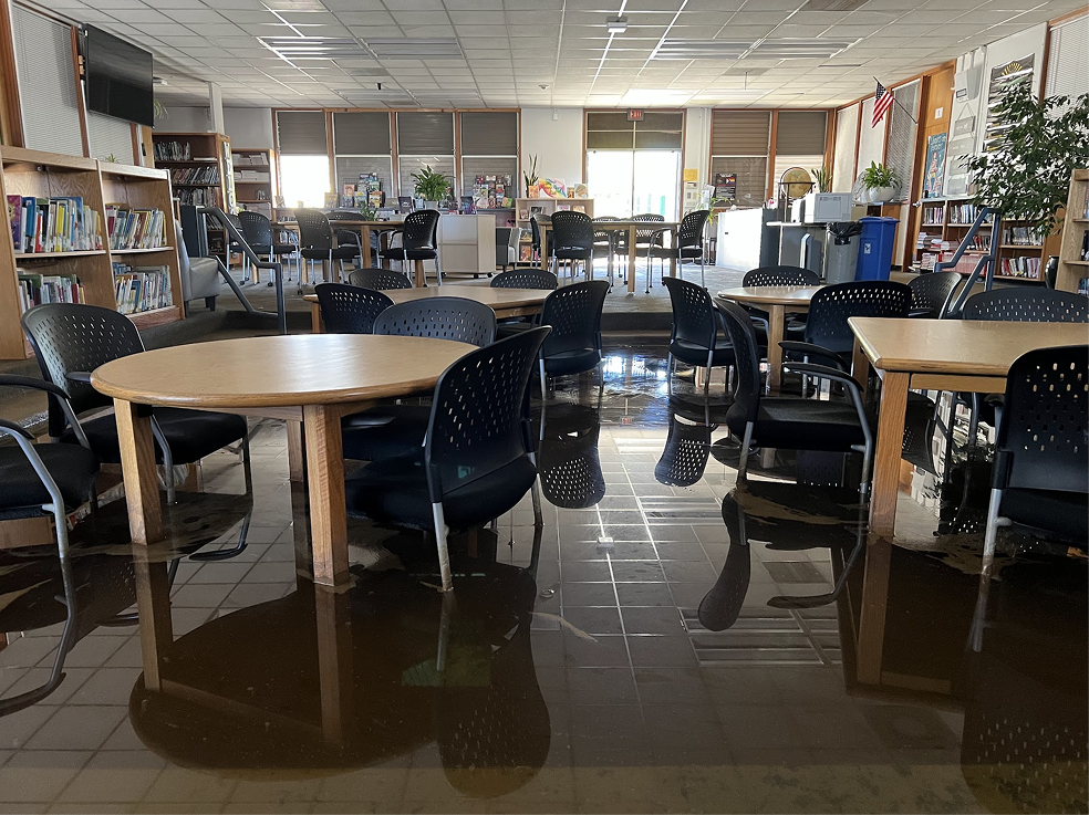
Conducting interviews at Pajaro Middle School and delving into the archives at Pajaro Valley Historical Association
Synthesis
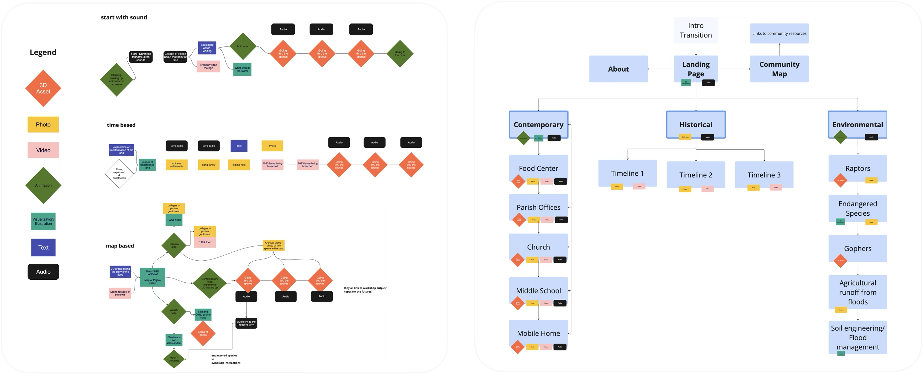
Once we had gathered a critical mass of research, I facilitated design sprints to explore narrative directions and visual strategies.
Outcomes from facilitated narrative ideation sessions and site architecture mapping
Design Approach
Initial Concept
From the site architecture, I created low-fidelity wireframes and prototypes to guide the experience. The central design concept was built around a metaphor of geological layering, to reflect the complex nature of the historical, environmental, and human factors in Pajaro’s flooding. Users could uncover successive interactive layers to explore deeper into the narrative:
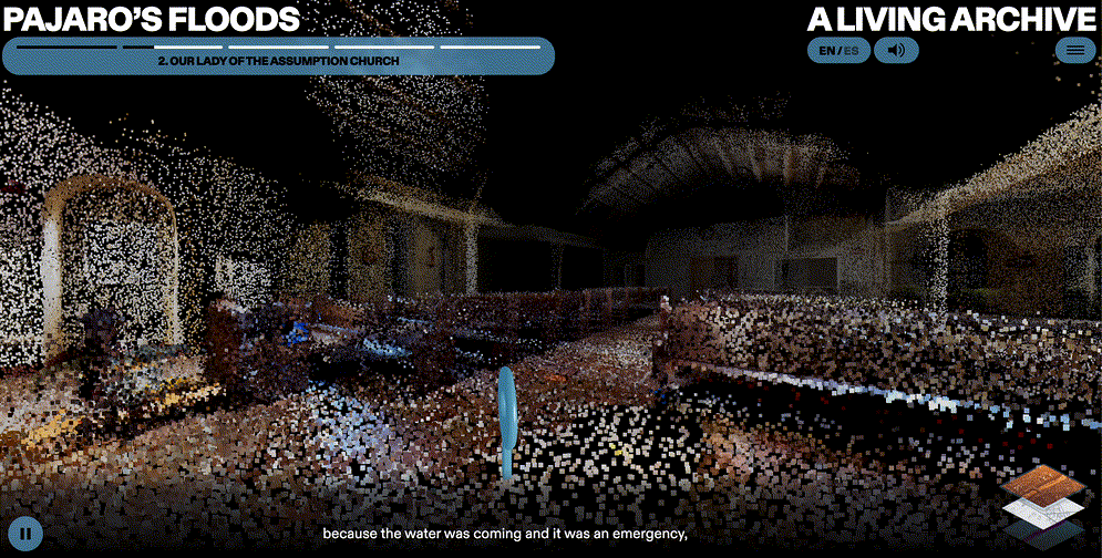
Contemporary Layer: Stories from the most recent 2023 flooding event with location based personal archives, ambient sound, and narrative audio.
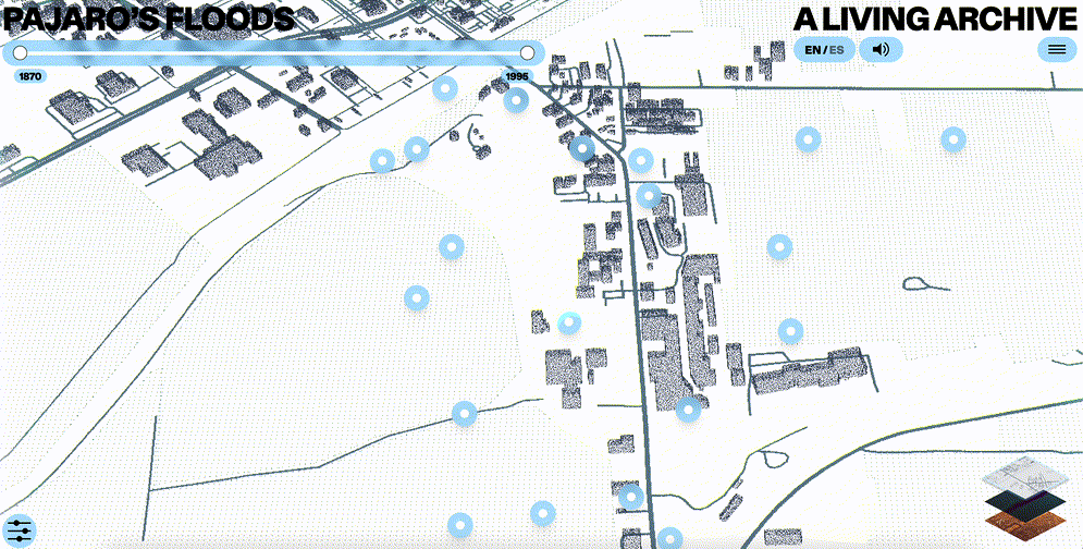
Historical Layer: Decades of archival media synthesized and mapped by events into main themes or cycles such waves of immigrant groups, the crops they grew, and the floods that impacted it all.
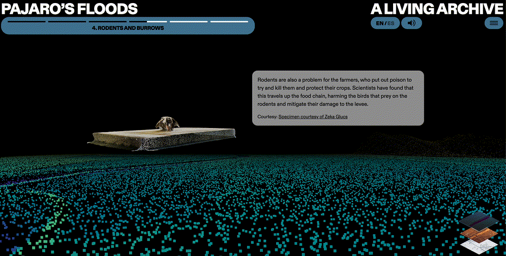
Environmental Layer: Following the river’s path through a soil-based perspective to look at the different interconnected ecologies and research being conducted there. The soil map was developed using Terra Forma’s framework, in collaboration with our illustrator.
Low-fidelity wireframes of the flow for a scene in the contemporary section
The initial wireframes helped iterate on the narrative and interaction layouts based on feedback. The experience design of the site was crafted with fading point clouds and ambient audio to evoke memory, water, traces, and the temporal nature of place.
Asset Creation
I led the integration and processing of diverse data sources, personal archives, scientific datasets, GIS, LiDAR, and satellite imagery, to build the project's immersive visual landscape. This included:
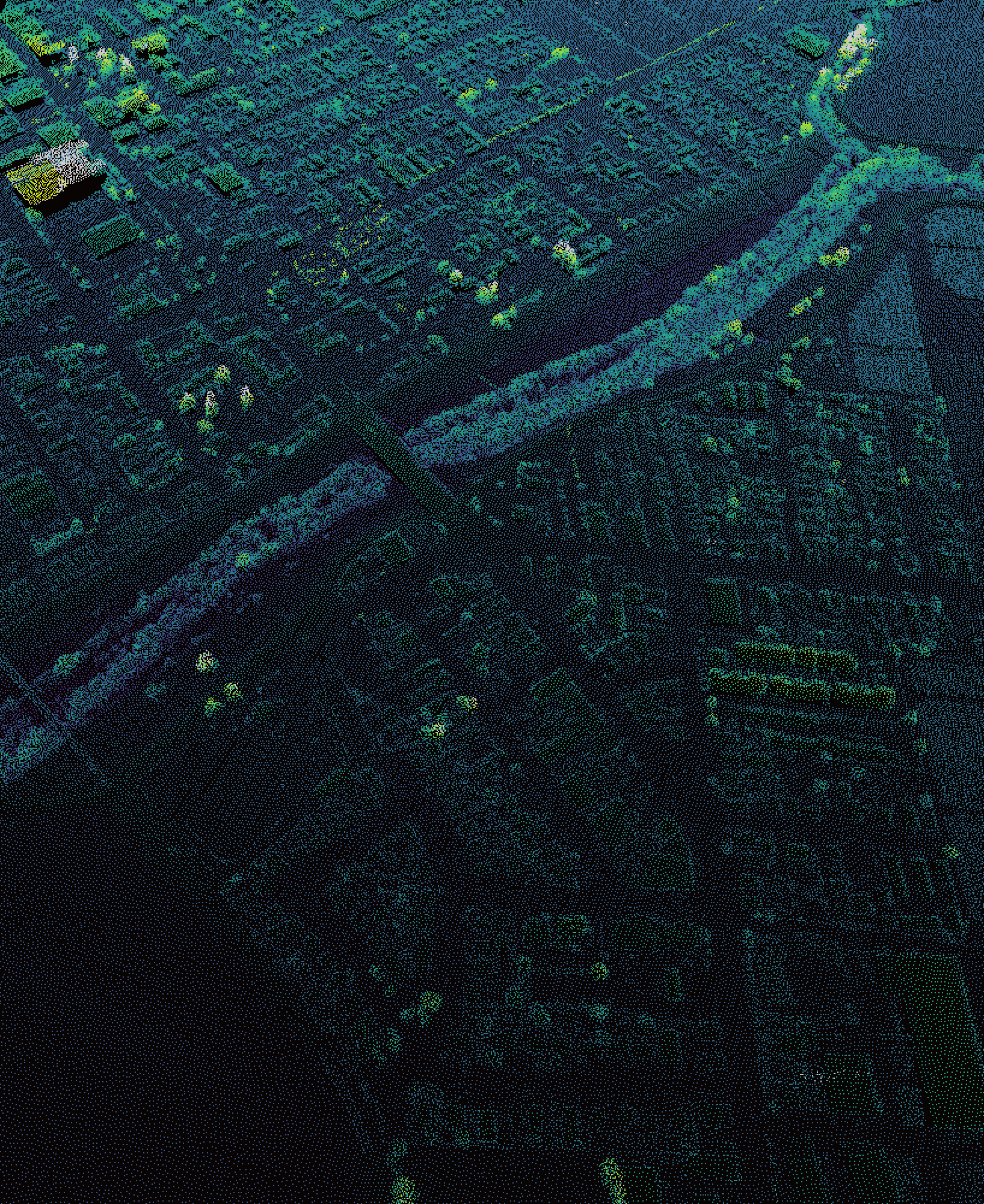
Processing satellite, GIS, and LiDAR scanning data to generate accurate 3D models of Pajaro’s flood-impacted geography and create layered spatial scenes of important community landmarks.
Cleaning and curating personal archives and their audio-visual assets to align with specific locations in the narrative pathways and contribute to site-specific sensory experiences.
Working across Blender, Unity, and CloudCompare to develop a fixed camera path through scenes that balanced our narrative structure with moments of user-driven exploration along a fixed camera path.
Creating photogrammetry of specimen data and incorporating maps and datasets from interviewed scientists to support visual communication of complex environmental considerations
Video recordings of prototype demos for developer handoff
Key UX Features
The UX aimed to balance a multi-layered, immersive experience with accessibility for a multilingual, digitally diverse audience. A key challenge was preserving the project's abstract and metaphorical elements while ensuring the clarity and intuitiveness users needed to navigate and understand the narratives.
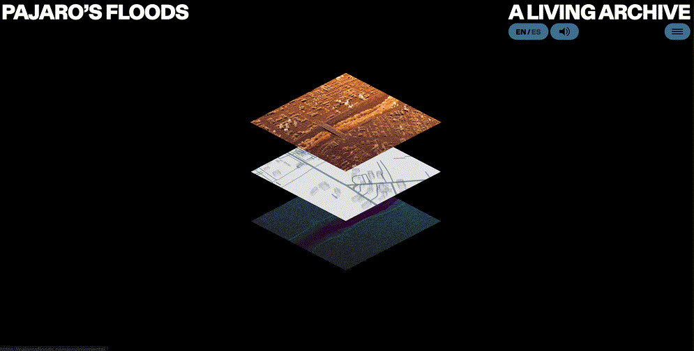
Map layer navigation on home page
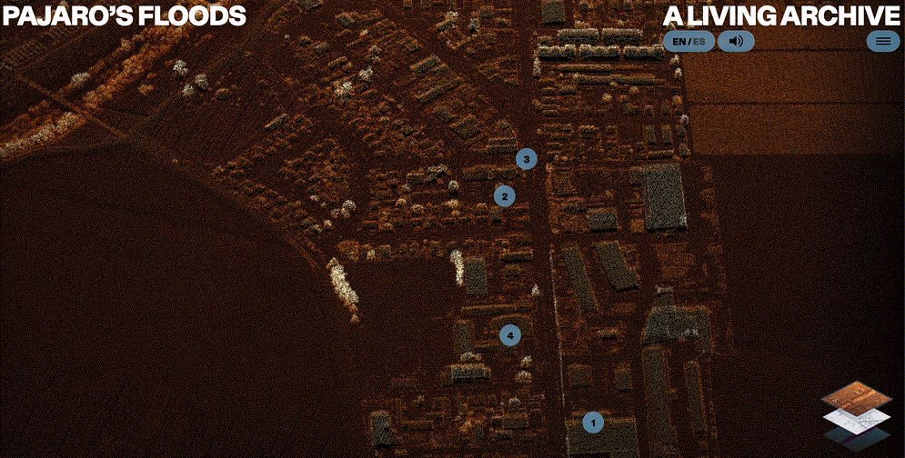
The same underlying map view was used throughout each layer to maintain consistency and build spatial knowledge and awareness. The main page featured a strata-like icon, allowing users to jump between layers visually building upon a 3D point cloud map of Pajaro.
Contemporary layer with point cloud map
An area for filters allowed users to categorize assets from the Pajaro Valley Historical Association by the synthesized themes (people, crops, and flooding). A toggle between icon and image view offered visitors options between a minimal layout and one with richer visual information.
Historical layer with filters
The main interactions included clicking location icons and swiping to zoom forward within 3D spaces (present in both contemporary and environmental layers), designed to feel intuitive across desktop and mobile devices. State changes and subtle text provided onboarding and wayfinding without overwhelming users.
Contemporary scene location icon interaction
Environmental Layer scrolling and 3D interactions
The interface supported bilingual navigation (English and Spanish), with voiceovers for key sections in Mixteco (a primarily oral Indigenous language spoken by many farmworkers in the area).
Bilingual navigation and voiceovers
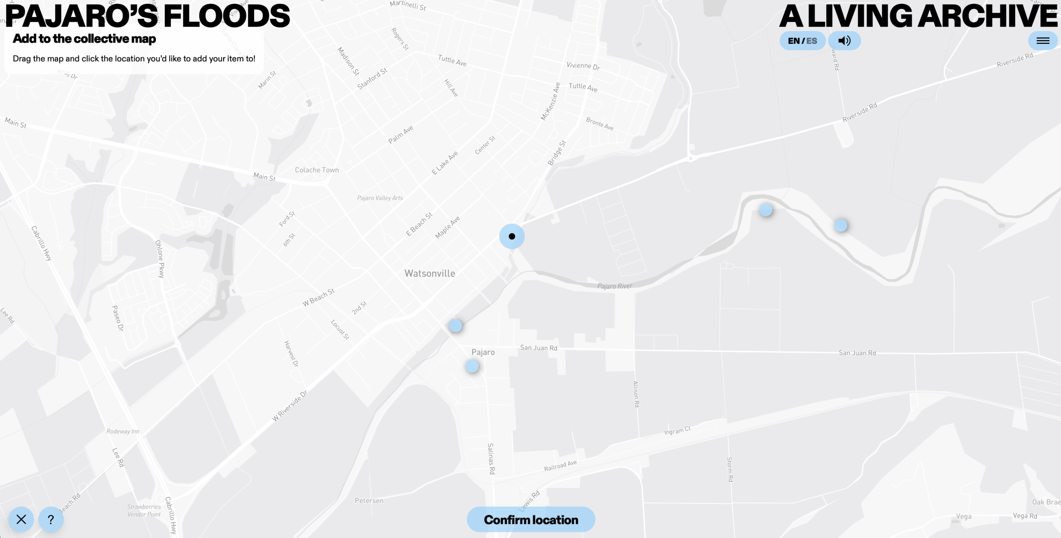
The participatory community map provided a space for visitors to contribute stories, images, or geolocated videos to add to collective memory for the place. A supporting toolkit included open instructions on flooding and mapping resources as a template for future adaptation or engagement.
Collective Map and Toolkit
Project and Product Management
I led the developer search, interviewed candidates, and drafted contract workflows for the external agency we ultimately hired. To bridge differences between their waterfall process and the agile approach the project needed, I negotiated an initial prototype scene, our riskiest and most experimental component, as a proof of concept before committing to the full design and development. I also scoped and prioritized development tasks, wrote and managed tickets, and handled QA testing to ensure functionality and quality.
Development and Implementation
I coordinated a multi-disciplinary team, including a creative agency in London, an illustrator and collaborators in California, while based in Europe myself, to bring the project from concept to production. I wrote briefs, led design reviews, finalized Figma files for development, and navigated technical and cultural challenges including:
Managed cross-disciplinary collaboration across design, development, illustration, sound, and translation using Trello and Notion.
Aligning different working styles, balancing an agile approach with the creative agency’s waterfall approach, and negotiating with external developers to deliver a prototype ahead of full-scale rollout.
Navigated technical constraints in 3D environments, optimizing for performance and browser limitations.
Prioritizing core features such as the participatory community map and narrative layering while downscoping VR for community accessibility and performance.
Created novel ways of synthesizing and presenting layered information e.g. developing the environmental section’s introductory map using Terra Carta’s soil framework
Adapted to changing team roles and priorities as coordination challenges affected workshop and audio planning.
Testing and Iteration
Web and mobile views of introductory screens
I facilitated quick usability testing with six users across varying levels of experience in new media, flood management, and California’s local history. Feedback revealed a need for clearer signposting to guide first-time users, differing priorities on degrees of freedom within scenes, and better mobile optimization. I revised the design to prioritize clarity while maintaining narrative depth, including:
Quotes and Narratives: Curated and translated bilingual quotes for emotional clarity, placing them at the start of scenes to convey the narrator’s perspective.
Navigation and Signposting: Provided interaction instructions and tooltips, surfaced site layers more clearly, and scaled back abstract elements to enhance usability and legibility across different user experience levels.
Interaction Design: Limited scene turning freedom to reduce disorientation; added pause, scrub, and revisit functions for pacing flexibility.
Mobile Optimization: Refined layouts and interactions for mobile-first access, recognizing that most community users engaged via smartphones.
Future plans include discussions on adapting the Living Archive toolkit to other climate-impacted communities, developing the immersive element further, and presenting the project in academic and public contexts. The project was recently recognized as a Webby Honoree and presented at the By Design and by Disaster conference.
In Closing
This project deepened my understanding of climate storytelling and independent creative leadership. I managed cross-cultural and cross-functional communication, worked closely with local communities, and navigated difficult vendor relationships, all with limited institutional support. Developing a novel, few-of-its-kind project with no pre-existing distribution pathway pushed us to explore new avenues for launch and impact, some of which are still unfolding.

.png)
.png)


.png)